

Cité de Carcassonne
Cité de Carcassonne Photo - Jondu11 -
Wikipedia - lic. under GFDL

Castle Facts:
Location: Carcassonne, in the Aude departement of France (Languedoc-Roussillon Region).
Built: --
Condition: In good condition.
Ownership / Access: --
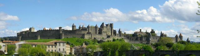
Notes: Cité de Carcassonne is a medieval architectural complex that is located in the French city of Carcassonne in the department of Aude, Languedoc-Roussillon region of Midi-Pyrénées. It is located on the right bank of the Aude, south-east of the present town. This walled medieval city, which dates back to the Gallo-Roman period, is renowned for its double enclosure, reaching nearly 3 km long, comprising fifty-two towers, which dramatically overlooks the Aude Valley. The city also has a castle (the count's castle) and a basilica (the Saint-Nazaire Basilica).
Saved from destruction by the action and tenacity of the archaeologist Jean-Pierre Cros-Mayrevieille, then restored in the nineteenth century sometimes controversial so under the direction of Viollet-le-Duc then Boeswillwald, Carcassonne city is, since 1997, World Heritage of UNESCO. The Count's Castle, fortifications, and towers owned by the state and managed by the Center for National Monuments, while the lists and the rest of the city are part of the municipal area.Carcassonne city is situated on the right bank of the Aude overlooking the city of Carcassonne located west. It is located between the Black Mountain and the Pyrenees on the axis of communication from the Mediterranean Sea to the Atlantic Ocean. The presence of two mountains form the corridor carcassonnais often cited when climatologists speak of the wind blowing in this corridor. This location is a strategic location in southern France to monitor this major way of communication: north to the Black Mountains, south to the Corbières to the west towards the Lauragais plain and east the plain wine to the Mediterranean.
The city is built at the end of a small plateau formed by the widening of the Aude to about 150 meters above the lower town. The first vessel built by the Visigoths following the depressions of the ground. This tray is detached from the Corbieres massif in the town of Palaja to 260 meters, going into the city to 148 m and ends up in the Aude 100 m9. On the west side, the slope is steep with a difficult access to potential attackers. In the East, the slope is gentle and allows easy access of goods, but also attackers. Also, the most important defense mechanisms are on this side of the city.
How To Get To Cité de Carcassonne (Map):
Cité de Carcassonne Links:
Cité de Carcassonne On Wikipedia
Have You Visited This Château? Please Comment Below: